Reducing flood risk by working with nature: PhD research being put into practice to help plan catchment flood mitigation strategies
PhD researcher Peter Metcalfe, based at Lancaster University’s Environment Centre (LEC), has been working on new methods to predict the impacts of “natural” measures to mitigate flood risk.
Peter brought with him many years of experience in technical software development and a background in computer modelling in the process engineering and aerospace industries. In the course of the PhD Peter has developed and published applications of a number of hydrological and hydraulic models that can be applied at a variety of scales and contexts within the water catchment. These include Dynamic TOPMODEL (Metcalfe, 2015, 2016) for simulation of rainfall and storm run-off and a coupled hydrological –hydraulic framework that can used to evaluate the effectiveness of distributed flood mitigation schemes (Metcalfe et al., 2017).
Peter’s research advisors are Keith Beven of LEC, Barry Hankin of JBA Consulting and Rob Lamb of the JBA Trust. Here, Peter discusses his research and how it is already being applied in practice.
In 2016 I worked with Barry, Rob and a team at LEC and the Rivers Trust to evaluate the potential for upstream flood mitigation measures in the Cumbrian catchments badly affected by the storms of the winter of 2015-2016. This work extended the approaches and models developed in the course of my PhD and combined them within a framework that included the JBA JFlow+ 2D flood inundation model (Lamb et al, 2009), stakeholder collaboration and uncertainty estimation. This project built on the approach pioneered by JBA for flood prevention in the Eden and which won Defra’s modelling innovation competition (see the winning entry here, Hankin et al., 2017).
The exceptional series of events in winter 2015-2016 led to the flooding of over 16,000 homes in Scotland and the north of England and caused damage likely to exceed £1.5 billion (Marsh et al., 2016). During the passage of Storm Desmond, on 5-6 December 2015, a new 24 hour record rainfall total of 341mm was recorded at Honister Pass and previous record peak river flows were exceeded in over half of the gauge network in the North West of England.
The defences in Carlisle and Keswick, upgraded after the severe storms of 2009 to withstand a “1 in 200 year” event, were overwhelmed. The 1680m³/s recorded at Sheepmount Weir in Carlisle exceeded the previous recorded maximum by almost 11%, having a return period of greater than 200 years (Marsh et al., 2016). The flood defence scheme in Kendal dating from the 1970s failed to prevent the flooding of over 2100 homes.
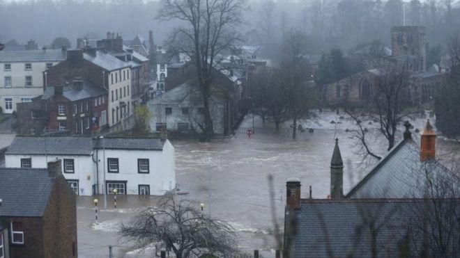
Flooding in Cumbria, December 2015 (Credit: Owen Humphreys/PA WIRE)
Climate models suggest increased winter total rainfall and lower but more intense summer rainfall in NW Europe (Ramsbottom et al, 2012). The solution to the problem of flood risk is clearly not to build bigger and more extensive downstream defences, even if it this were feasible in the current capital-constrained environment. Approaches are now being adopted that instead apply a range of techniques that enhance natural processes within catchments upstream of affected areas in order to reduce water yield or retain storm run-off in the landscape and release it slowly and so attenuate the passage of a flood wave downstream. This approach has become known as Natural Flood Management or NFM (Environment Agency, 2014).
NFM interventions include hillslope tree-planting to intercept rainfall and increase evaporation losses, soil and peat structural improvement to prevent fast saturated surface run-off, emplacement of wooden barriers or earth dams (bunds) to intercept overland flow and tree planting in floodplains to slow overbanked flow. Other measures to reduce river velocities and increase channel storage include placement of large woody debris (LWD), “leaky” dams, barriers or engineered log jams (ELJs).
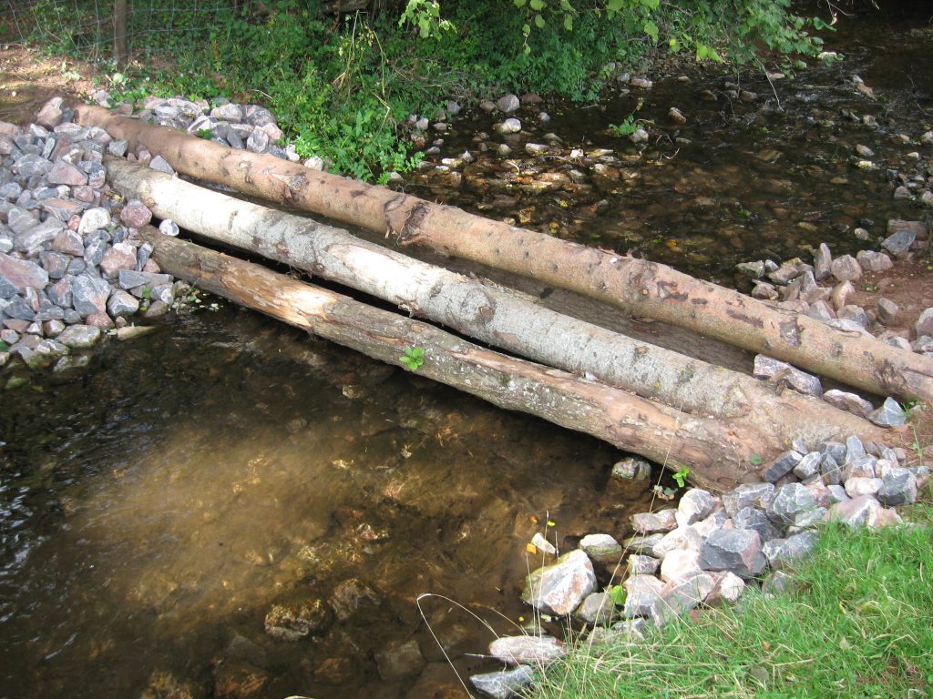
Large woody debris dam – Paddock Weir, Holnicote, Devon (Credit: Steve Rose, JBA Consulting)
JBA Trust have collated information for over 150 NFM-type schemes in the UK (see https://naturalprocesses.jbahosting.com). An evidence base for the effectiveness of NFM approaches during realistic flood events is still lacking, however. Many schemes are found in the South and East of the country and were not stressed during the events of 2015-2016, for example. It will take a number of years before schemes utilising tree-growth to reach full effectiveness, so the impacts of these will be difficult to quantify. It has been suggested that incorrect placement of measures, including tree planting to slow overbanked flow, could lead to previously asynchronous flood waves from tributary subcatchments becoming synchronised. Modelling tools will therefore be required to enable planners and catchment managers to make strategic decisions on where to place NFM measures and to be able to test these against a range of potential storms, including those derived from climate change models. Not all rainfall events will impact a scheme in the same way and the effect of antecedent conditions can have a significant influence on its performance.
I developed a model to assess various configurations of flood mitigation scheme in a catchment in North Yorkshire that employed in-channel leaky dams or barriers (Metcalfe et al., 2007). This analysis showed that some configurations could prevent flooding in a single-peaked event of the type commonly employed as a design storm in assessing run-off models. However, when applied to a double-peaked event that caused flooding in 2012, the scheme ran out of capacity during the second storm while the barriers were still draining. Using the results of the model, I helped to design an actual NFM scheme in this catchment and the first features were put in place in summer 2016.
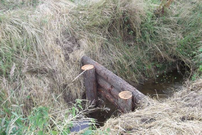
Recently installed leaky ditch barriers in Brompton, North Yorkshire (Credit: Sue Butler, Brompton Flood Group)
The collaboration with LEC, JBA and the Rivers Trust utilised the approaches and models developed in the course of my PhD in combination with a screening stage and a collaborative stakeholder approach in order to evaluate the potential for NFM interventions in the upper Kent, Eden and Derwent catchments. By simulating the system’s response to a set of rainfall event scenarios, 2D modelling was used to screen the catchments for opportunities for NFM measures. The screening identified areas where increases in surface roughness achieved by restoring peat or by tree planting (selected from the Woodland For Water opportunity maps, Nisbet et al., 2011) could provide benefits in flood mitigation. Also identified were accumulation areas indicated the potential for small scale storage. The selected sub-catchments ranged in size from just under 100km² to over 200km².
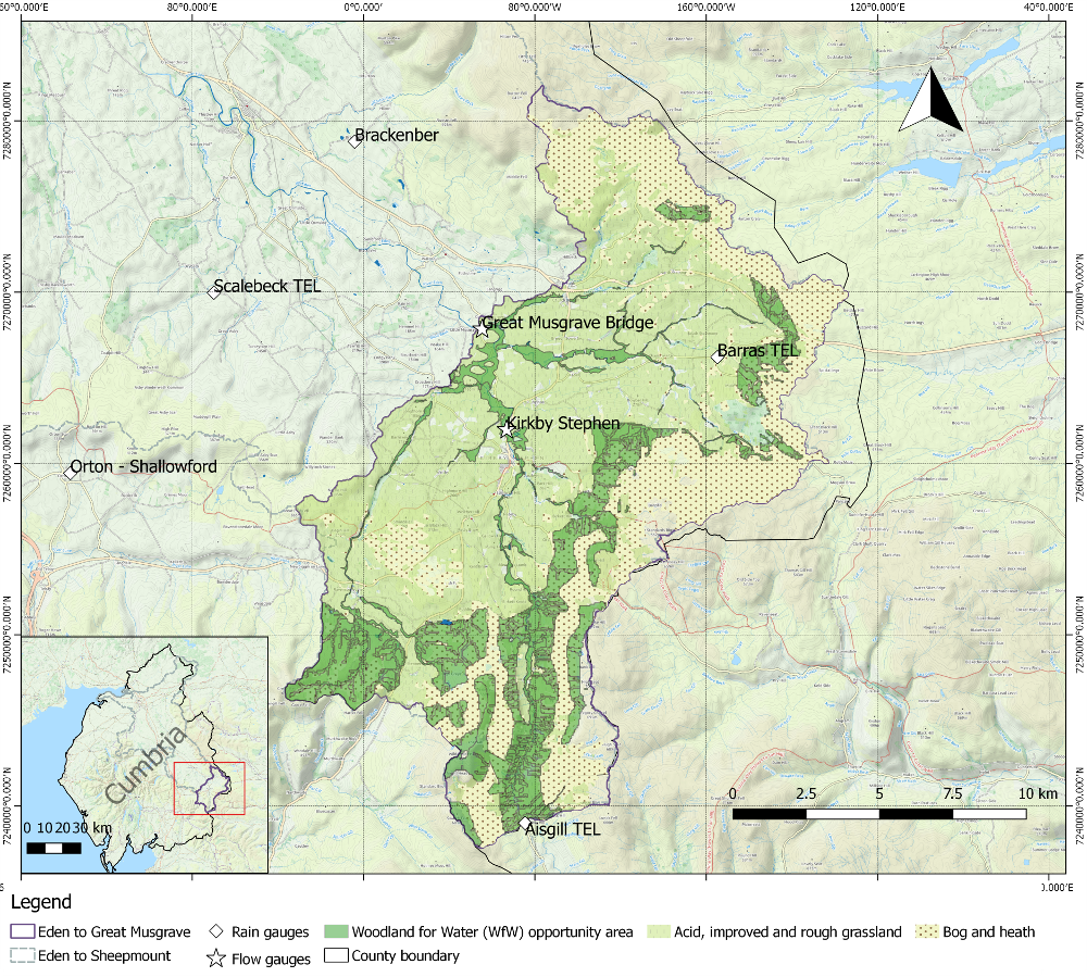
Map: Eden headwaters to Great Musgrave Bridge, the largest of the three Cumbrian catchments modelled in the study. Appleby is a few mile downstream from the outlet gauge. Existing grass and bog and heath and scrub cover shown along with areas identified for tree-planting opportunities from the national Woodlands for Water (WfW) dataset. These cover approximately 23% of the catchment area, in contrast to the present 2.5% occupied by trees.
My implementation of Dynamic TOPMODEL was then applied thousands of times with varying parameters across a calibration period containing the storms Abigail, Barney and Desmond. This gave a set of simulations that closely matched the actual stream flows, with a probability weighting reflecting the likelihood of the simulation matching the “true” catchment state across the period. The implementation was modified with an improved surface routing algorithm so that the effect of inserting overland interception Runoff Attenuation Features (RAFs) could be investigated. It was also improved so that it could model the effects of increased evaporation of rainfall intercepted by the tree canopy (wet canopy evaporation). The baseline set of simulations was re-run with a range of parameter value shifts to reflect feasible effects of these measures on the catchment processes within the affected areas in order to give an indication of possible impacts of the NFM interventions and the likelihood of these impacts being achieved.
The project determined that with interventions in all of the catchments NFM measures could have had a significant effect, even during the most extreme events, with some simulations indicating a reduction of 15% in the peak of Storm Desmond. Wet canopy evaporation contributed the largest amount to the attenuation. It showed the significance of antecedent conditions: the peaks of Abigail close to the start of the period were reduced by up to 45%. This suggests that hillslope tree-planting could provide flood risk mitigation benefits particularly in the summer and early autumn by means of the increased soil moisture deficits it produces. The impacts reduce as the ground approaches saturation through the course of the winter.
The modelling framework I developed is now part of new research proposals seeking to extend the approach to a wider range of catchments and NFM intervention types, applied over wider scales, thereby aiming to fill important evidence gaps about NFM.
More information about the outputs of Peter’s PhD can be found here.
References
Environment Agency, 2014. Working with natural processes to reduce flood risk. R&D framework. Report SC130004/R2. Bristol: Environment Agency.
Hankin, B., Lamb, R., Craigen, I., Page, T., Chappell, N., Metcalfe, P., (2017). A whole catchment approach to improve flood resilience in the Eden LINK
Nisbet, T., Silgram, M., Shah, N., Morrow, K., & Broadmeadow, S. (2011). Woodland for water: woodland measures for meeting water framework directive objectives. Forest research monograph, 4, 156.
Lamb, R., Crossley, A., Waller, S., (2009). A fast 2D floodplain inundation model. Proceedings of the Institution of Civil Engineers: Water Management, Volume 162.
Marsh, T.J., Kirby, C., Muchan, K., Barker, L., Henderson, E. and Hannaford, J. (2016). The winter floods of 2015/2016 in the UK – a review. Centre for Ecology & Hydrology, Wallingford, UK.
Metcalfe, P., K.J. Beven, and J. Freer, (2015). Dynamic TOPMODEL: a new implementation in R and its sensitivity to time and space steps, Environmental Modelling and Software, 72: 155-172.
Metcalfe P., Beven, K. and Freer, J. (2016). dynatopmodel: Implementation of the Dynamic TOPMODEL Hydrological Model. R package version 1.1. LINK
Metcalfe, P., Beven, K., Hankin, B. & Lamb, R. (2017). A modelling framework for evaluation of the hydrological impacts of nature-based approaches to flood risk management, with application to in-channel interventions across a 29km² scale catchment in the United Kingdom. In press, Hydrological Processes.
Ramsbottom, D., Sayers, P., & Panzeri, M. (2012). Climate change risk assessment for the floods and coastal erosion sector. Defra Project Code GA0204. Report to Defra, London, UK.
Wilkinson, M.E., Quinn, P.F., Welton, P., 2010. Runoff management during the September 2008 floods in the Belford catchment, Northumberland. Journal of Flood Risk Management, 3(4): 285-295.