Analysis of local authority areas where planting trees could help reduce flood risk
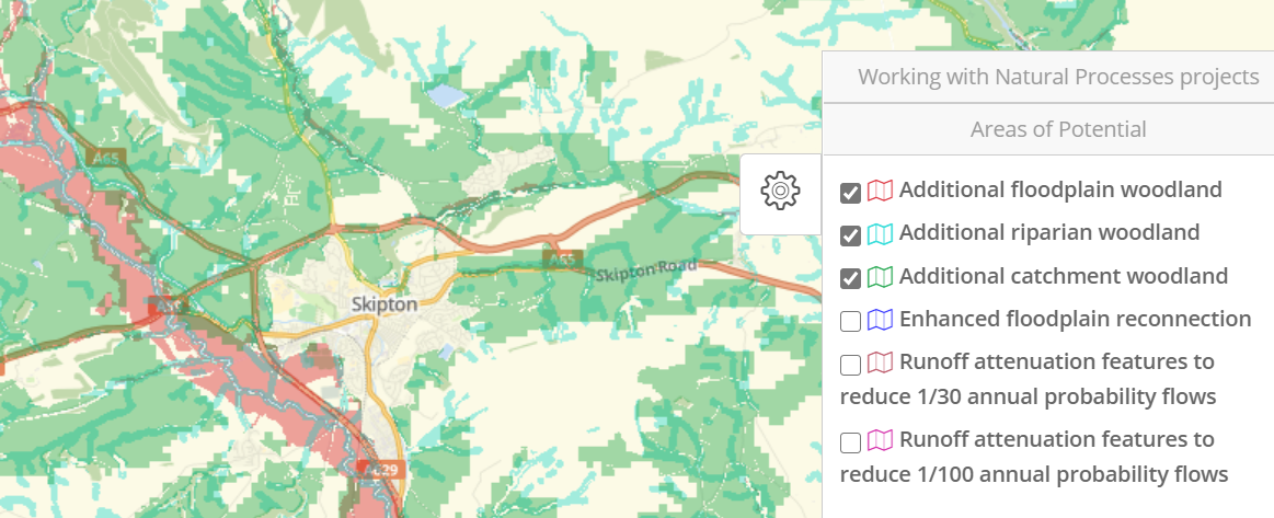
Our interactive mapping website includes indicative, strategic maps published by the Environment Agency about where there is the potential to work with nature to reduce flood risk in England.
There are a variety of river and catchment management approaches that can be used when working with natural processes to reduce flooding. These include temporarily holding water back in the catchment using small-scale runoff attenuation features, reconnecting the river with the floodplain and planting trees.
The maps show that over 36% of England’s land area has the potential for reducing flood risk by growing more trees, equivalent to over 4.8 million hectares. We have looked at the spread of this potential across local authorities.
How do trees affect the flow of water in a catchment?
Planting trees in a catchment can help increase infiltration of water into the soil, slow the overland flow of water by creating rougher ground and intercept rainfall in the leaf canopy.
Trees can also be planted on the floodplain to dissipate the energy in flowing flood waters (Dadson et al. 2017) and hold flood water back for longer, which tends to reduce the peak flood flow.
Planting trees in the riparian zone immediately around watercourses may also help to slow the flow of water (Broadmeadow et al. 2014), as well as creating buffer zones that reduce the amounts of sediments and excess nutrients entering the river.
Where might planting trees help reduce flood risk?
Our interactive map includes the three ‘woodland’ layers where the Environment Agency’s data show potential for different types of tree planting that may be able to contribute to reducing flood risk:
- Floodplain woodland: This map layer shows the areas in Flood Zone 2 (with constraints)
- Riparian woodland: This map layer shows the area 50m either side of a watercourse (with constraints)
- Wider catchment woodland: This map layer was generated from an analysis of the presence of slowly permeable soils (with constraints)
For each layer, the constraints that were applied during development of the maps eliminated areas considered unsuitable for new tree-planting, for example existing woodland, peat, roads, railways, buildings and waterbodies.
A technical report on how the map layers were generated is available here.
Which local authorities have the greatest areas of potential for tree planting to reduce flood risk?
Our analysis considered how much land in each local authority area has the potential for planting trees to mitigate flood risk, according to the Environment Agency data.
We found that Northumberland, Shropshire and Eden District are the local authorities with the largest total area (a combined total of 492,000 hectares).
Islington London Borough, Brighton and Hove, and Lambeth London Borough had the smallest areas (a combined total of just less than 1 hectare).
The data used for the local authority analysis is available to download here.
There is uncertainty about the effectiveness of tree planting in reducing flood risk.
Research syntheses (see below) show that evidence about the influence of trees on flood risk is complex, with different studies coming to a range of conclusions, leading to uncertainty about the scale of potential flood risk reduction benefits. Research is continuing in many projects to gather more evidence and understand better how tree planting affects flood risk.
Research synthesis studies
Citations
BROADMEADOW, S.B.; THOMAS, H., AND NISBET, T.R., 2014. Opportunity mapping for woodland creation to reduce diffuse water pollution and flood risk in England and Wales. Farnham, Surrey: Forest Research.
DADSON S.J., HALL, J.W., MURGATROYD, A., ACREMAN, M., BATES, P., BEVEN, K., HEATHWAITE, L., HOLDEN, J., HOLMAN, I.P., LANE, S.N., O’CONNELL, E., PENNING-ROWSELL, E., REYNARD, N., SEAR, D., THORNE, C. AND WILBY, R., 2017. A restatement of the natural science evidence concerning catchment-based ‘natural’ flood management in the UK. Proceedings of the Royal Society A, 473 (2199), 20160706; DOI: 10.1098/rspa.2016.0706