Projection Augmented Relief Model (PARM)
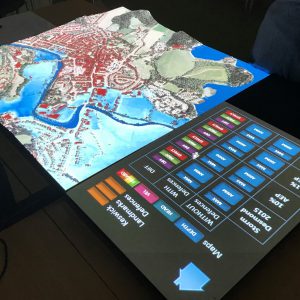
A PARM consists of a 3D printed scale model of a landscape, based on LIDAR data, with a projector that overlays information onto the 3D model.
We have been developing these models to look at flood risk and help people understand flooding in their area. They can be used when new flood alleviation schemes are being considered, as a means to engage with the public and the community.
Using a 3D model makes it easier to visualise flood risk and the benefit of flood defences. Lots of different types of information can be projected onto the 3D map, meaning the model is easily adaptable and flexible to meet different users’s needs.
In 2017, JBA Consulting worked with the School of Geography at the University of Nottingham to develop a PARM that shows the impact of different rainfall events and flood defence scenarios in Keswick, UK. The aim is to use the PARM to engage local communities and support decision making for flood defence schemes.
JBA Trust is now carrying out research in partnership with Professor Gary Priestnall at the University of Nottingham as part of an ESRC funded Impact Accelerator project.
The project aims to understand how effective PARM techniques are in communicating both general flood risk concepts and complex catchment specific flood modelling outputs to a non-technical audience. We hope that our research will provide evidence to support wider uptake of PARM techniques in engagement and outreach activities and enable practitioners to use these resources to raise awareness and optimise learning outcomes.
If you are interested in seeing a demonstration of the PARM, or even commissioning one, please email info@jbatrust.org to discuss.
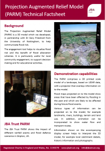
Factsheet: Dimensions, demonstration requirements and other vital statistics for the PARM are available in this factsheet.
Find out about our other physical models here, and watch other JBA Trust videos on our YouTube channel.
Learning resources

Learning Resources: Rivers
Learning resources to help understand how engineered structures in the river channel, like culverts, screens and weirs, affect water flow and local flood risk.

Learning Resources: Catchments
Learning resources to help explore how different landscapes and land uses can affect how water flows and the risk of flooding

Learning Resources: Weather and climate
Learning resources to help understand the principles of weather monitoring, why it’s important and how this links to weather hazards and our changing climate.

Learning Resources: Coasts
Learning resources to help explore how different types and combinations of coastal defences can improve resilience to coastal flood risk and erosion.